
After a very intense morning at the sulphur-filled Kawah Ijen, our next destination was the far more popular Mt. Bromo - another of Java's volcanoes west of Ijen. We had our Jeep driver from Ijen drop us at the Banyuwangi bus station, where we argued over the price of a ticket to Probolinggo (I'd read that the price should be 30,000 Rp, or just over $2, but the tout tried to charge us 70,000. In the end, we only got the price down to 60,000). The bus was hot, but not too crowded, and I slept for the first few hours. We ended up having to change buses, although no one had said so beforehand, but the second bus wasn't packed either. I watched out the window as we passed through the beautiful Javanese countryside: pine forests, rice fields, and small towns surrounding beautiful mosques. We arrived at Probolinggo around 5 in the evening, and without much trouble (everyone knew why we were there), we were directed to an agent who could arrange a bus up to Cemoro Lawang, the starting point for Bromo treks. The agent was extremely helpful, providing us with a map of the hiking trails, tips on avoiding the national park entrance fee (he told a similar story as the guides at Komodo National Park: the national government has recently raised the park entrance fees, but seems to be just pocketing the extra profit, without providing any extra services or maintenance, so the park rangers occasionally help tourists evade what they see as corruption), and even booking us an onward bus for a few days later. Unfortunately, he was not extremely helpful in arranging the bus up to the village, explaining that we'd have to wait for more tourists to arrive, since the bus wouldn't take just the two of us. Luckily, he said, there was a trainload of people arriving at 8, and the bus would be happy to take us with them. We were reluctant to wait three hours, so he offered to lead us to another bus, where seven people were waiting. We arranged with the driver to pay a bit more since we still weren't a full load, which was a bit annoying, but we were happy to get a move on. There are a couple of decent places to stay in Cemoro Lawang, but the majority of the accommodation is homestay-style, and those are notoriously crummy. The one we ended up in was no exception, but we were tired enough after our early start and long hours of travel that we decided to put up with it for the night.
 |
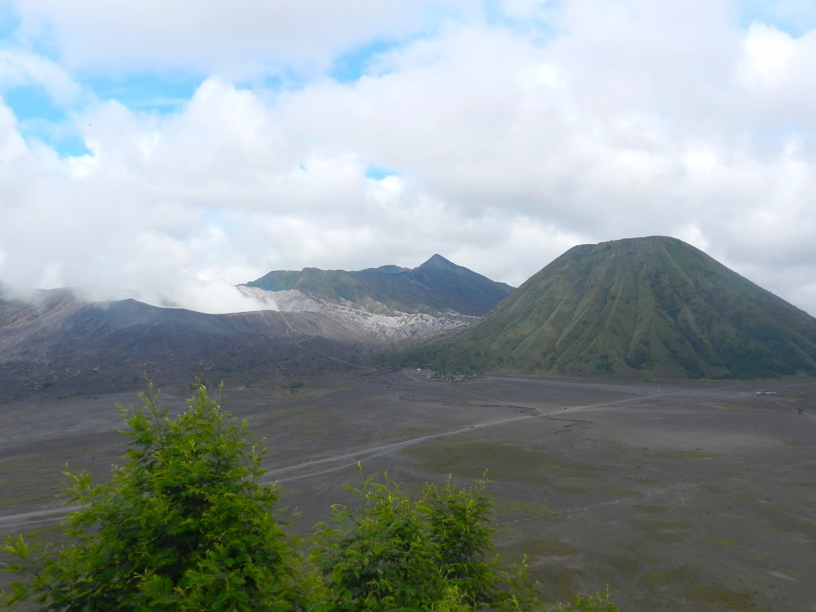
| Bromo and Batok |
In the morning, we headed to one of the cleaner hostels for breakfast, and found that they had an open room (they'd been full the previous night), so we decided to move there for our second night. The room was still small, and pricier than it was worth, perhaps, but the space was clean and the showers were hot. After we'd moved our bags and gotten settled, we spent the day walking to see Mt. Bromo's crater. We learned that the guards at the gate to the park don't typically ask for the fee after the sunrise crowd, and especially not to people on foot (many choose to approach the crater via motorbike or on horseback, but the walk is easy and not too long). We followed the main road and came to a small lookout point where we could see the caldera below us, with Mt. Bromo and neighbor Mt. Batok rising out of the ashy caldera floor. Mt. Bromo was small, but its size was redeemed by the curls of smoke rising from the top of it. Batok was much taller and completely green, contrasting with the barrenness of the rest of the caldera. The road descended steeply into the caldera, and from there the expanse of black soil spread out in front of us, the flat caldera floor punctuated there and there by mountains, and a series of cracks that traced the lava flow from Bromo's most recent eruption. As we approached Bromo itself, we passed the Hindu temple at the foot of Mt. Batok, and waved off the many people selling peanuts and offering horseback rides up to the mountain.
 |
| On the caldera floor |
 |
| A peanut seller walks across the caldera |
 |
| Hindu temple and Mt. Batok |
 |
| Staircase to crater |
From the foot of Bromo is a staircase up to the mouth of the crater. Prior to the 2011 eruption, it was possible to climb down into the actual crater, but these days, tourists must content themselves with a glimpse over the edge. Near the top of the staircase, we started to smell the sulphur (but nothing compared to Kawah Ijen!). From the guardrail running around the crater, we could see the clouds of smoke pouring out of the mountain. Whenever it cleared somewhat, making it possible to see deeper inside, we could see that the walls of the crater were grey, with lines of bright yellow sulphur rock. We stayed up there for quite some time, watching the smoke and surveying the landscape below. Then we made our way back down and across the caldera, to the main road. By the time we'd reached the hostel, the fog that had been moving in all day had descended so that the mountains were invisible. We spent the rest of the day relaxing and walking a bit in the tiny village. We had another sunrise to prepare for.
 |
| Mt. Bromo cater |
 |
| Sulphur streaked in the rock |

We'd heard that the clouds in the caldera blocked the sunrise view completely the day before we'd planned to head up, so it was with only a little hope that we headed out at 4 am. Many people had organized a jeep to take them up to see the sun, but we were determined to make the walk, so, map in hand, we set out along the pitch black road. The stars were magnificent, and I thought that might be a good omen for a clear sky when the sun came up. It was an easier walk than Ijen: the road was only a slight incline at first and, though it did get steeper along the way, it was never as strenuous as Ijen's first few kilometers. We reached a small lookout, but it was still too dark to see anything but the shadows of the mountains around. From there the road became even rougher and steeper. Suddenly, we met a huge and noisy school group, who'd come up by bus and was now getting ready to walk the rest of the way (from there the road became stairs so it was inaccessible except on foot). The stairs wound back and forth on the mountain, and were by far the toughest part of the hike. As the sky lightened, there were a few clouds, but we had a clear shot of the caldera below us, and of Mt. Semeru behind it. Semeru is Java's tallest volcano - 3700 meters, and about 15000 meters higher than Bromo. It is an extremely active volcano, and the smoke drizzling out of its crater makes it appear to have a small cloud floating perpetually above its peak. In the dawn, the mountain appeared pink and light purple. As the sun started to rise, the whole valley lightened from grey to pale green to bright green. Once the sun had cleared the ridge to the east of us, the view was breathtaking - the whole caldera spread out before us. We stayed about an hour at the top, completely entranced by the sight.


No comments:
Post a Comment